


The primary planning requirement during a Search and Rescue (SAR) operation is knowledge of the likely search area in which targets may be found. The determination of search areas is not straightforward in an environment where the prevailing meteorology and oceanography complicates target trajectory. The Θ-SAR platform provides rapid and near to perfected predictions of the movement of drifting objects and missing persons at sea. It includes among others the ability to deploy search & rescue units (SRUs) with search patterns and calculate probability of containment (POC), probability of detection (POD), and probability of success (POS).
Supports commercial all nautical charts (BSB NOAA Charts/MapTech Charts/NDI Charts NOS Charts/British Admiralty (ARCS) Charts/C-MAP Charts integration), open data, satellite images and owned by organization layers.
Θ-SAR Modules
➢ Web based tool NOT connected with a single license can used by multiple users simultaneously.
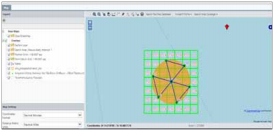
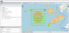
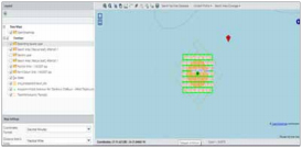
➢ Search Planning Tool.
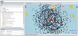
➢ IAMSAR and Monte Carlo methods for computing drift.
➢ Datum point, Datum line and back track search methods.
➢ Combine multiple resources for a single or multiple search target(s).
➢ Cumulative POS and optimization tools to maximize probability of success Integrate prior/subsequent searches to improve in future/successive search planning.
➢ Export KML files containing every necessary Θ-SAR info for use by, out of the organization network, personnel.
➢ Results output to reports.
Θ-SAR has been designed to operate anywhere in the world. Using in-built databases of oceanography (based on best available tidal and ocean current data) and electronic charts. Θ-SAR can be applied by any search and rescue authority in the world.
As well as the ability to use preconfigured databases, Θ-SAR can import gridded ΜetΟcean data in the internationally recognised NetCDF data format. Automatic import of this type of data can dramatically increase the system’s accuracy and speed up model set-up times.